Within Routes
When Should You Ignore a Suggested Route?
Drivers sometimes need to ignore a suggested route when safety risks or local conditions conflict with the app's recommendation.
On this page
- Unsafe Road Conditions
- Hidden Local Hazards
- Balancing Safety and Speed
Page outline Jump by section
Introduction
Navigation apps and AI route planners are useful because they can process traffic information far beyond what any individual driver can see. However, they are not observing the road through a driver’s eyes. When a visible hazard suggests that a recommended route is unsafe, the driver should prioritise the real-world situation over the digital instruction. Understanding this distinction is an important lesson in understanding artificial intelligence: AI can make informed predictions, but it cannot always recognise immediate conditions that are obvious to a human being on the scene.
 A suggested route should generally be ignored when continuing would expose road users to a clear and present safety risk, such as flooding, road collapse, emergency activity, obstructed visibility, fallen debris, or conditions that make the road unsuitable for the vehicle. In these situations, the safest decision is often to stop, reassess and choose an alternative route, even if the app indicates that continuing is faster.
Unsafe Road Conditions
The clearest reason to disregard navigation advice is the presence of a visible hazard that was not reflected in the route calculation.
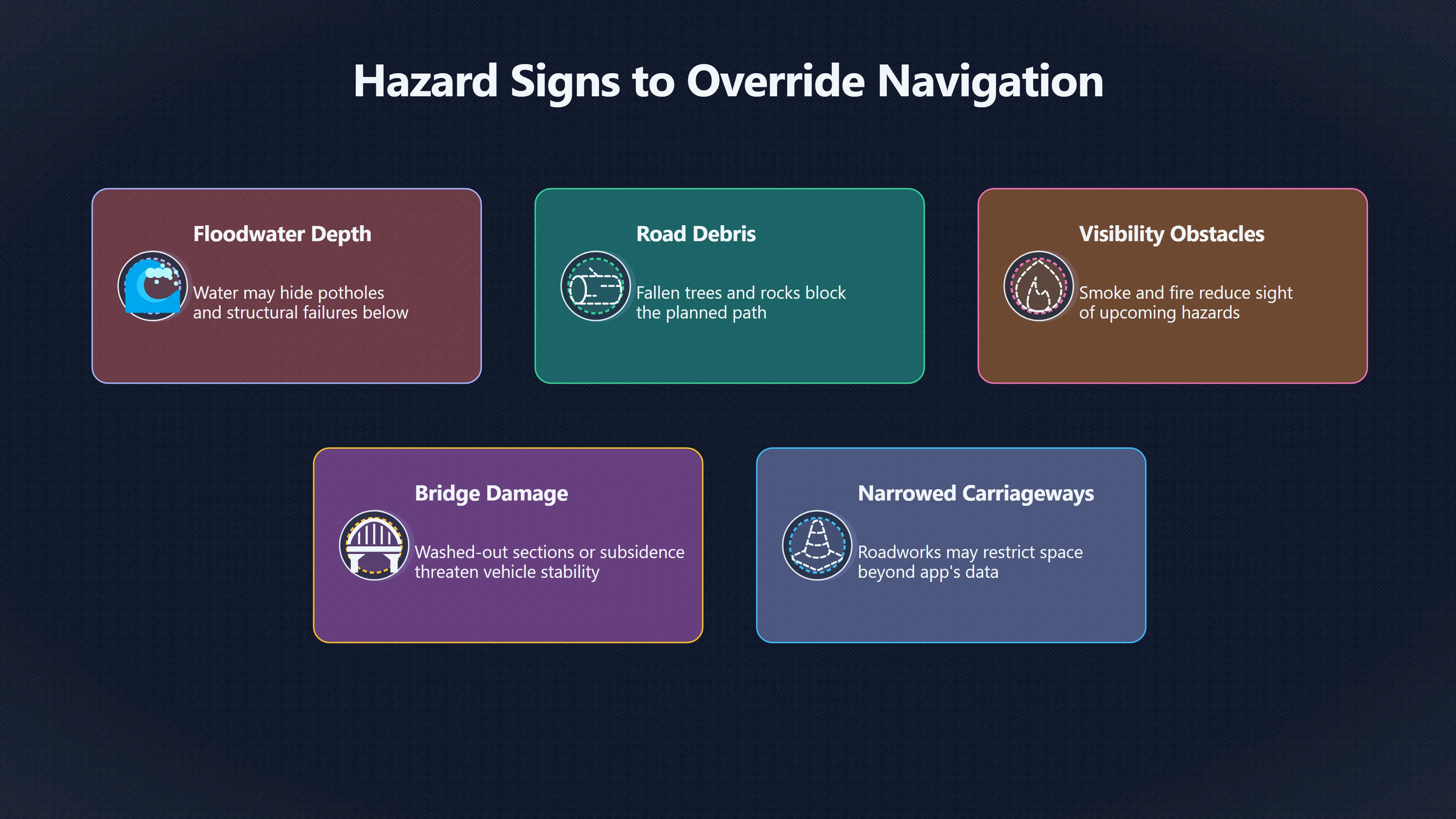
Flooded roads are one of the most common examples. Navigation systems increasingly incorporate flood reports, but real-world conditions can change faster than map data. Floodwater may conceal potholes, damaged road surfaces, open drains or structural failures beneath the surface. Transportation and flood-safety authorities consistently warn that roads covered by water can become impassable or dangerous even when they appear shallow. Research on flood-affected transport infrastructure has documented vehicle losses, road failures and severe safety consequences when drivers attempt to continue through floodwaters. [cdema.org+2consorsegurosdigital.com]cdema.org3 2 2 roads in flood areas3.2.2 Roads in flood affected areas15 Jul 2016 — There will be a disruption to the road network, risk to vehicles and passengers trying t…
Other visible conditions that should override navigation instructions include:
- Fallen trees, rocks or debris blocking the roadway.
- Smoke, fire or wildfire activity reducing visibility or threatening the route.
- Ice, snow drifts or standing water creating obvious loss-of-control risks.
- Damaged bridges, washed-out sections of road or visible subsidence.
- Roadworks that have narrowed or obstructed the carriageway beyond what the app indicates.
- Severe congestion caused by an incident where emergency access is required. [transportation.gov]transportation.govITS use casesimprove emergency vehicle access…
In each case, the driver possesses information that the navigation system may not yet have received. The AI’s recommendation is based on incomplete data, while the driver is observing the hazard directly.
Hidden Local Hazards
Some dangers are visible only when approaching the location and may never appear accurately on a route map.
Rural roads provide a useful example. Navigation systems often divert traffic onto narrow country lanes to avoid congestion. Yet those roads may contain sharp blind bends, agricultural vehicles, livestock crossings, overgrown vegetation, poor sight lines or unexpected single-track sections. UK road-safety organisations have warned that sat-nav diversions can place unfamiliar drivers onto roads with substantially greater risk than the roads they are trying to avoid. Recent road-safety analysis noted that rural roads account for a disproportionate share of fatal collisions despite carrying a minority of total traffic. [The Times]thetimes.comThe Times Safety alert over sat-navs diverting drivers on to country roadsThe charity highlights that while these diversions may save only a few minutes, they significantly increase the risk of accidents. In 202…
Visibility is particularly important. Road-safety guidance notes that limited forward visibility increases the likelihood that drivers will be unable to react in time to hazards. Vegetation, road geometry and temporary obstructions can create risks that are impossible for a routing algorithm to judge accurately from traffic data alone. [National Highways]nationalhighways.co.ukNational HighwaysGuide to Road Safety Route Treatments March 2025June 5, 2025 — forward visibility, there is a greater risk of road users…
Drivers should therefore be cautious when an app suggests:
- An unfamiliar shortcut through narrow rural roads.
- A route that appears unsuitable for the size of the vehicle.
- A diversion through an area affected by recent severe weather.
- A path that conflicts with temporary warning signs, barriers or instructions from road authorities.

When Emergency Situations Change the Priority
Navigation systems are designed primarily to optimise travel. During emergencies, safety becomes more important than efficiency.
If emergency vehicles are approaching, if police are directing traffic, or if responders have closed part of a road, official instructions should take precedence over the app. Emergency management agencies and transport authorities increasingly use connected technologies to communicate hazards, but those systems are not universal and may not reach every navigation platform immediately. Research on emergency routing repeatedly highlights that road closures and rapidly changing conditions can create information gaps between the field situation and routing systems. [FHWA Operations+2IEREK Press]ops.fhwa.dot.govFHWA Operations Implementing Solutions for Emergency RoutingFHWA OperationsImplementing Solutions for Emergency RoutingFebruary 22, 2024 — Encourage State DOTs to expedite weight and roadside safet…
A driver who can see flashing lights, emergency personnel or temporary barriers is receiving higher-quality information than a route planner that may still assume the road is available.
Balancing Safety and Speed
The difficult decisions usually occur when the hazard is not a complete blockage but a visible increase in risk.
A navigation app might suggest a diversion that saves five minutes. Yet if that diversion leads onto a flooded lane, a poorly maintained track, or a road where visibility is severely reduced, the time saving becomes irrelevant. The route recommendation is optimising for travel time, while the driver must evaluate safety, vehicle capability and comfort. Road-safety experts have increasingly argued that drivers should actively question whether small time savings justify exposure to greater risk. [The Times]thetimes.comThe Times Safety alert over sat-navs diverting drivers on to country roadsThe charity highlights that while these diversions may save only a few minutes, they significantly increase the risk of accidents. In 202…
A practical rule is simple:

- Treat navigation advice as a recommendation, not a command.
- Compare the recommendation with visible road conditions.
- Give priority to official signs, barriers and emergency personnel.
- If a hazard creates uncertainty about safety, choose the safer route.
- Report hazards through navigation platforms when possible so that future routing decisions improve.
This balance illustrates a broader principle of artificial intelligence. AI systems often excel at analysing large-scale patterns, but humans remain responsible for interpreting immediate reality. When the road ahead visibly contradicts the route on the screen, the safest judgment is usually the one based on what can actually be seen.
Amazon book picks
Further Reading
Books and field guides related to When Should You Ignore a Suggested Route?. Use these as the next step if you want deeper reading beyond the article.
The Official Highway Code
Directly relevant to judging hazards and safe driving decisions.
Hello World
Reinforces the idea that human judgment can supersede automated recommendations.
eBay marketplace picks
Marketplace Samples
Example marketplace items related to this page. Use the search link to explore similar finds on eBay.


Endnotes
-
Source: cdema.org
Title: 3 2 2 roads in flood areas
Link: https://www.cdema.org/virtuallibrary/index.php/charim-hbook/use-case-book/3a-critical-infrastructure/3-2-design-guidelines/3-2-2-roads-in-flood-areasSource snippet
3.2.2 Roads in flood affected areas15 Jul 2016 — There will be a disruption to the road network, risk to vehicles and passengers trying t...
-
Source: consorsegurosdigital.com
Title: Floods, a danger to road safety
Link: https://www.consorsegurosdigital.com/almacen/pdf/floods-a-danger-to-road-safety.pdfSource snippet
ConsorsegurosDue to their [speed]({{ 'speed/' | relative_url }}) and unpredictability, flash floods are extremely hazardous to personal safety, specifically to road safety...
-
Source: press.ierek.com
Link: https://press.ierek.com/index.php/Resourceedings/article/view/946Source snippet
IEREK PressRouting and Navigation Solutions for Emergency Vehicles...by C Ozcan-tatar · 2023 · Cited by 3 — The application is developed...
-
Source: transportation.gov
Title: ITS [use cases]({{ ‘use-cases/’ | relative_url }})
Link: https://www.transportation.gov/grants/ss4a/ITS-use-casesSource snippet
improve emergency vehicle access...
-
Source: thetimes.com
Title: The Times Safety alert over sat-navs diverting drivers on to country roads
Link: https://www.thetimes.com/uk/transport/article/sat-nav-safety-alert-country-roads-3pg963gdnSource snippet
The charity highlights that while these diversions may save only a few minutes, they significantly increase the risk of accidents. In 202...
-
Source: nationalhighways.co.uk
Link: https://nationalhighways.co.uk/media/viad3j1n/guide-to-road-safety-route-treatments.pdfSource snippet
National HighwaysGuide to Road Safety Route Treatments March 2025June 5, 2025 — forward visibility, there is a greater risk of road users...
Published: June 5, 2025
-
Source: ops.fhwa.dot.gov
Title: FHWA Operations Implementing Solutions for Emergency Routing
Link: https://ops.fhwa.dot.gov/publications/fhwahop22030/fhwahop22030.pdfSource snippet
FHWA OperationsImplementing Solutions for Emergency RoutingFebruary 22, 2024 — Encourage State DOTs to expedite weight and roadside safet...
Published: February 22, 2024
-
Source: GOV.UK
Title: www.gov.uk The Highway Code
Link: https://www.gov.uk/guidance/the-highway-code/general-rules-techniques-and-advice-for-all-drivers-and-riders-103-to-158Source snippet
Highway Code - General rules, techniques and advice...1 Oct 2015 — You MUST NOT use hazard warning lights while driving or being towed u...
-
Source: GOV.UK
Link: https://www.gov.uk/guidance/flood-risk-and-coastal-changeSource snippet
risk and coastal changeAdvises how to take account of and address the risks associated with flooding and coastal change in the planning p...
-
Source: highways.dot.gov
Title: infrastructure developing [risk based]({{ ‘risk-rules/’ | relative_url }}) scour program
Link: https://highways.dot.gov/fed-aid-essentials/videos/other-programs/infrastructure-developing-risk-based-scour-programSource snippet
dot.govInfrastructure: Developing a Risk-Based Scour Program | FHWAThis online training provides guidance on developing a Plan of Action...
-
Source: assets.publishing.service.gov.uk
Link: https://assets.publishing.service.gov.uk/media/5a7d8038e5274a676d532707/safety-at-streetworks.pdfSource snippet
at Street Works and Road WorksThis Code of Practice (referred to from here on as the Code) is intended to help you to safely carry out si...
Additional References
-
Source: rospa.com
Link: https://www.rospa.com/road-safetySource snippet
Road safety advice and informationA vast array of advice and information on all areas of road safety covering drivers, riders, pedestrian...
-
Source: clearview-intelligence.com
Link: https://www.clearview-intelligence.com/wp-content/uploads/2024/10/Route-safety-solutions-brochure-digital-.pdfSource snippet
Route Safety SolutionsThis case study focuses on minimising road accidents resulting from excessive speed, limited visibility, complex ju...
-
Source: facebook.com
Link: https://www.facebook.com/groups/WantageAndGroveCommunity/posts/1505266390184511/Source snippet
Waze app helps report flooded roadsSimply enter your route into Waze App and it will show you all REPORTED hazards including flooded road...
-
Source: facebook.com
Link: https://www.facebook.com/groups/964805740341395/posts/3509053489249928/ -
Source: naturalhazards.com.au
Link: https://www.naturalhazards.com.au/crc-collection/downloads/enhancing_resilience_of_critical_road_infrastructure_-_final_project_report_may_2021.pdfSource snippet
enhancing resilience of critical road structures: bridges...by S Setunge · 2021 · Cited by 1 — The research conducted included assessme...
Published: may 2021
-
Source: tomtom.com
Title: building road network resilience how to keep moving through disruption
Link: https://www.tomtom.com/newsroom/explainers-and-insights/building-road-network-resilience-how-to-keep-moving-through-disruption/Source snippet
Moving through disruptions in Urban spaces20 Jan 2026 — Real-time floating car data revealed functional roadways through a heavily damage...
-
Source: benton2.org
Title: Benton County Fire District No 2HAAS Alert Safety Cloud
Link: https://www.benton2.org/haas-alert-safety-cloudSource snippet
Benton County Fire District No 2BCFD #2 emergency vehicles can now send real-time alerts to drivers when units are responding to or opera...
-
Source: instagram.com
Link: https://www.instagram.com/reel/DZZkXCjndsG/Source snippet
Not all safety alerts are created equal Behind every alert in...When a route includes a vehicle restriction, HERE SDK Navigation provide...
-
Source: facebook.com
Link: https://www.facebook.com/firenuzzle/posts/navigating-flooded-roads-can-be-dangerous%EF%B8%8F%EF%B8%8F-always-assess-the-water-depth-avoid-/455278910811416/Source snippet
water to recede. Floodwater can hide dangers, damage...Read more...
-
Source: youtube.com
Title: Turn around, don’t drown: Safety tips for driving amid flooding from Debby
Link: http://www.youtube.com/watch?v=8_VzMM3gc0gSource snippet
Google maps fail flooded stream gps driver EPIC GPS FAIL! Car Plunges into Frozen Canal in Indianapolis Snipjolt...
Topic Tree